


Leave a Reply
Want to join the discussion?Feel free to contribute!
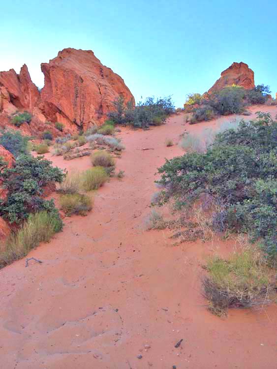
Babylon Arch trail is a very sandy, but very gratifying trail. It doesn’t take long on the trail to feel like you have landed on Mars with all the cool sandstone formations around you, and the arch is very unique compared to any I have seen before. This hike is NOT stroller friendly, but young kids can make the trek with help. The trail forks and will take you to the arch or to the Virgin River. It doesn’t take much longer to do both and the river is refreshing and fun to look at! This one is definitely worth the trip!
Moderate
1.5 miles from Primitive Camping Area
1-1.5 hours roundtrip
Primitive Camping Area Trailhead: 37.206290, -113.329849
Sand Cove Trailhead: 37.209486, -113.335957
Babylon Arch: 37.202500, -113.334917
BLM, Red Cliffs Desert Reserve
21 Miles (33 minutes driving)
No Restroom Available
Yes
Yes, on 6 ft leash
No
Yes
Out & Back
Spring, Fall, Winter
Morning, Afternoon
No Limit
No Permit Required
No Cost
No Water Sources Available, Stream/River Along Trail (Purify & Filter Before Drinking)
No Camping Available on Trail, Camping Available only in Designated Camping Area
Dirt Single Track, Sandy
Full Sun Exposure
Directions to Trailhead. From St George, head north on I-15 for about 13 miles and take exit 22 to Leeds/Silver Reef. Head north on Hwy 228/Main Street for 2 miles and take a right onto 900 North (there is a sign indicating Red Cliffs National Conservation Area). Follow 900 North for about 3 miles and turn left after the sign indicating Sand Cove Trailhead.
You can take the trail from two start points – Sand Cove Trailhead, or the Primitive Camping Area Trailhead. 4WD and high clearance are REQUIRED to get to the Primitive Camping Area. Even the road to the Sand Cove Trailhead is pretty sandy and 4WD or at least AWD is recommended. If you continue to the Primitive Camp Area, then go on passed the Sand Cove Trailhead for a few hundred feet and take a right. Follow this road until you can’t go anymore and you’ll be at the trailhead!
Plants: Typical plant life for Southern Utah lowland hiking.
Animals: Typical animal life for Southern Utah lowland hiking.
We headed out early on a Saturday morning to beat the mid summer Southern Utah heat and got to the trailhead just after the sun peaked over Zion National Park. The sun was just starting to light up Red Cliffs Recreational Area as we parked the truck and hit the trail. You couldn’t ask for a more beautiful start of the day! We drove to the Primitive Camping Area so cut off some distance on the hike, and to test out the 4WD on my truck! We had a good time getting there, and upon arrival, started on the trail.
 From the beginning of the trail we were walking through patches of sand, and that was just a foreshadowing of the trail to come. (I must say, it is fun to go on an adventure where you know very little about the place you are going. I started this site/blog, as a means to give people the full picture of their adventure before they go, but there is a bit of excitement in just going and seeing if you can find what you’re looking for!) After rounding the first few rocks the trail before us opened up and we could see across the river to Sky Mountain, and the Navajo Sandstone rock formations were out of this world! I felt like I had landed on Mars and was treading in uncharted territory. It looked like someone had squeezed little piles of red sand all over the place and let them dry.
As we continued on our trek the sand got more loose and started filling our shoes. As we made our decent toward the river bottom we came to a little ridge that we had to drop down that was just a sand hill. What room we had left in our shoes was filled with sand and we made our way down. This point in the trail is important because there is a more prominent trail to the left, but we could see faint tracks going straight down to the right. We chose left, and we ended up at the river with no sign of an arch anywhere. I’m actually glad we went that way first because I had wanted to go down to the river. On our way back we noticed a fork in the trail and looked up, and about 100 yds away was Babylon Arch. We hadn’t seen it on our way down the trail because there was a large rock blocking our view.
 We approached the arch with excitement because we had been afraid that we would miss the thing we had come to see. As we approached it was not hard to notice that this arch was unlike any I had ever seen. Babylon Arch is not a typical arch you see in the side of a mountain somewhere. It looks like someone took a hole saw and bored through a huge rock. It is a almost perfectly round hole, and it is very interesting.
The arch is about 8 ft tall and 10 ft wide. We were able to walk right through it as if the rock had been positioned perfectly so the trail could pass through the middle of it. After taking a few pictures of the arch and surrounding rock formations we continued up the trail and were reminded why we decided to take the trail to the left on the way down! We were looking at a sand hill with a 60 degree pitch that we had to climb up (we could have turned around and gone back up the way we had come down, but we wanted the challenge). We made our way up in a step-slide fashion. Eventually we triumphed over the hill and felt good about our accomplishment amid our huffing and puffing.
After emptying our shoes we got back on the trail. It wasn’t far to go now. I looked around me again at the strange rock plop formations and admired their strange uniqueness as our vehicle came into view. This trail was a fantastic reminder that there is so much adventure and beauty to be found, if only I am willing to get out and embark on the journey. Add Babylon Arch to your list! You won’t be disappointed in the trip!
Until next time…your next adventure is right out your door!
HikeStGeorge is a project that began as a seedling for Tim LeBaron in the early part of 2008, but really didn’t begin to blossom until the latter part of 2011. The original idea behind the site was to bring to light all of the harder to find, or “less known” hidden gems of the area. It was more of a pet project than anything. As excitement about the site began to spread, there was more of a push to develop information about all hikes in the Southern Utah Region.

 Toquerville Falls
Generally a great area to just wander around. We hiked down to the river first, and passed the arch on our way back. There are multiple ways to make the trip, but it’s pretty easy to orient yourself and find your way back to the parking area.
No chance to access by a camper? Any similar recommendations in Red Cliffs Desert Reserve?
Beautiful hike. Unfortunately, I didn’t find your site until after I completed today’s hike. I look forward to using your resources. Thanks for all your hard work in putting the site together.
No I haven’t but some at the Zion NP.Great work mate!!